Time to catch up with the past few weeks and the places we have been and seen. Whilst staying at Pakawau we took the opportunity to explore as much of the upper reaches of Golden Bay as we could.
A trip along Farewell Spit was an absolute requirement. So we took a trip with the longest existing Spit tour operator. We were a small party consisting of a couple from Singapore, the bus driver and ourselves. Talk about coincidence, his name was Roy and he worked in the IT industry in Singapore!!!!
We were picked up at 7am and then proceeded to spend the next six hours exploring the Spit and surrounds.
Farewell Spit is some 27 kilometres long and between 700 metres and one kilometre wide for much of it’s length, much bigger than we had envisaged.

Looking back along the ocean Beach toward Cape Farewell.

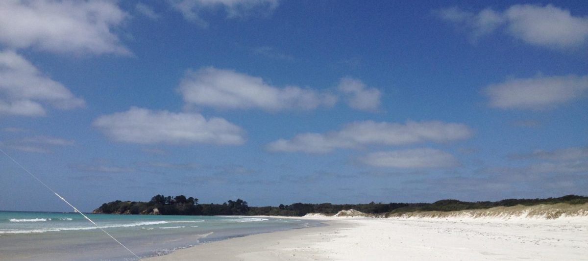
The ocean beach disappearing into the distance looking toward the ocean end of the spit. The ocean beach is all sand for its whole length. The inner beach is more mud and sand as it accumulates the debris brought down the rivers emptying into Golden Bay. There is also significant ground cover, trees and grasses over much of the Spit on the inner side protected from the ocean by a long range of sand dunes.

Wild life on the Spit was somewhat restricted at this time of year as we were too early for the return of the migratory flocks of birds returning to New Zealand and the Spit. We saw a number of seals, young and old.

No this is not a dead baby seal, just one protecting itself from the wind and sunburn by allowing the blown sand to form a barrier. It did acknowledge our presence by turning its head to follow our movement.
Toward the end of the Spit there is a lighthouse and the remnant buildings used by the lighthouse staff and farm owners in later days. We had our muffins and tea break at this point. The lighthouse is still operating but is now totally automatic.


Some idea of the scale of the lighthouse can be gauged from the height of the person at the base of the lighthouse.

The light in the lighthouse has also been modernised. As a result the original Fresnel lens is now on display in a hut at the base of the lighthouse.

The lighthouse keepers house is still in good repair and is used by DOC, naturalist, biologists, and other scientists interested in the wild life, geography and geology of the Spit and the changing nature of the Spit

Visitors in front of the skeleton of a pilot whale at the lighthouse area. Whale strandings are common at the spit occurring every year, often more than once per year, all of these occur on the inner beach rather than the ocean beach.

Patterns etched by wind and water in the sand on the top of the sand dunes

On the return trip we paused by one of the largest sand dunes and climbed it to view the outlook and gauge the size and extent of the dunes. The above view looks toward the inner side of the spit and gives a perspective to the width of the spit


Some people were practising their skiing, not quite so expert at arriving at the base of a face of the sand dune.
After returning from the far reaches of the Spit we made our way to Cape Farewell the northernmost point of the South Island.

The hole in the rock at Cape Farewell

On the way back from the Cape we saw this Spur Wing Plover on the side of the road. She was protecting her off spring who can be seen in the background.
The following day we decided we would see what the road down the West Coast looked like from this end of the island. On the map we were to progress to Whanganui Inlet and then follow the coast down to Anatori which was about as far as one can go.

The Whanganui inlet is immense! the above picture is the outlet to the sea, but it gives no idea of the size of the inlet. It is a huge area that is virtually dry when the tide is out so that there is on immense movement of water every tide.

An old wharf structure on the shores of the inlet. Still used by a couple of fishing boats

How to build another wharf at the same spot by grounding an old barge

Around the inlet there are significant wetlands and old stands of cabbage trees a lot of which are unique looking.
We stopped for a picnic lunch at the mouth of the Paturau River. Obviously the locals welcome visitors but make clear the standards with which they are expected to conform!!

The clear list of expectations.

This unique seat is set up on a small rise giving a panoramic view of the beach below.

The road from Paturau River south was a relatively narrow metal road following the coast, very scenic showing a lot of tomos and caves and sink holes in the limestone which underlies the whole area.

Lime stone cliff faces and ranges at Mangarakau Swamp where we found a well set up swamp restoration project.

Looking down on River mouth between Paturau and Anatori.

Part of the collection of camp vehicles and huts for whitebaiters at the mouth of the river.

A great display of native clematis seen on the way back home to Pakawau


")


")
")


