Taipa, Coopers Beach and Mangonui

You know how much we love good food and how we like to support local growers around the country so it should not come as any surprise that we found out about local markets. Saturday morning and Farmers Markets were on in both Taipa and Mangonui so we  were off at a reasonable hour to attend.  The first stop was at Taipa, a small bay at the southern end of Tokerau Beach (which stretches for 18kms) all part of Doubtless Bay.   In 1769, Capt. James Cook sailed past the entrance to the area and recorded in his journal "doubtless a bay", hence the name. At the same time, the French ship St Jean Baptiste of François Marie de Surville was anchored within the bay. Each ship was unaware of the other.

We called in to the market at the local Hall, perused what was on offer, made our purchases then went to see the local beach.

34taipa_thumb35taipa_thumb

Taipa Beach

On the foreshore were a couple of interesting sights, first a couple of seagulls perched atop a sign and a mosaic covered monument which we think is a memorial. 

36taipa_thumb37taipa_thumb

From Taipa, it was on through Cable Bay and Coopers Beach. Cable Bay was thus named as it was the landing point for the first underwater telegraph cable (the red route) linking New Zealand with Australia, Canada and Norfolk Island. The telegraph station operated from 1902 to 1912.

39coopers_thumb40coopers_thumb

Coopers Beach

Then it is just a short drive over the hill to Mangonui, where there is another market to attend.  Of course we had to take photos of ‘the’ famous Fish & Chip shop on the waterfront, and under gloriously blue skies with the tide in and barely a ripple on the water it certainly was a picturesque sight.

41mangonui_thumb42mangonuifish_thumb

Iconic views

Back to the van overlooking Matai Bay, where we quite happily will stay for at least another week. 

Matai/Maitai Bay

We are confused, it’s not only us that don’t know how to spell Matai/Maitai Bay, it seems as those in the know don’t either.

43matai33maitai

The two maps we carry with us also has the different spellings so we guess its either/or.

And what a place, a stunning location which has been aided by the glorious weather, we just cannot believe that this is supposedly winter as we sit outside wearing shorts and T-shirts, basking in glorious sunshine soaking up the warmth.  The Bay itself is very sheltered with hardly a ripple seen on the water.  Our parking site is on the top part overlooking the Bay from about midway.

20northLooking north19southLooking south

One morning there was early morning mist providing good photo opportunities.

5mistatmaitai 6seamist

At the south end of the Bay is another part of the camping area which is a little soft underfoot at this time of the year but we did venture down to look back up the bay to where our vehicles are parked.

8north and vans 10vans

The vans in the middle of the Bay     A close up view

A day out and about was called for so we packed ourselves up to explore more of the Karikari Peninsular with the first stop Tokerau Beach.  This is a huge stretch of golden sand that seems to go on for miles.  We headed out to where we know motorhomes are allowed to park to see what the area is like.  We will definitely be coming here in the next week or two for a stay.  But as it is more exposed, we will have to make sure that we are here at Tokerau Beach when the winds are favourable.

11tokorau 12tokorau

Tokerau Beach looking north             and south

Up behind the beach at Tokerau and through the sand dunes is a large body of fresh water called Coka Cola Lake.  It’s not the bottom of the lake that is the colour of the popular beverage that is apparently best drunk with rum, it’s the actual water itself.  The area is surrounded by a lot of peat and it’s this evidently that gives it the colour.  The water is very soft and is supposedly very good  for your skin and hair. We shall report back later once we have checked out these properties.  The lake also provides great reflections on a still day.

14cokacolalake 15cokacola reflections

On our return journey we popped into Rangiputa Beach on the west side of the peninsular,  as this is a good bolt hole should the wind prove to be a problem on the east.

16rangiputa Rangiputa

Back to Matai Bay, where the hunter gatherers set out to see if they can gather up a feed of mussels from the rocks at the southern end of the bay.  We had seen a fishermen out on the rocks, not that we had watched him land any fish but we were hopeful.

23fisherLone fisherman

18greatwhitehunters   21whitehunters

The great white hunters out and about!!

Unfortunately the hunter gatherers returned with nothing in their catch bags, meanwhile the women had been dutifully collecting the wood to cook the spoils!  Ok, so we had the gas stoves ready to light but its the same thing isn’t it?

Another day, and this time a walk to the north end of the beach where we hoped to find evidence of collectable shellfish.  The waters were incredibly clear but alas no mussels to gather here.

25northclearwater

Clear waters

27pohutukawa28pohutukawa

Pohutukawa with what appeared at a distance to be flowers turned out to be dead leaves.

29bird32bird

And finally a couple of dotterels that obviously have a nest in the dunes as they were trying very hard to lead us away from a particular area on the beach.

Houhora to Kaitaia

OK I put my hand up, I did it! I ran into Roy!  Accidentally of course.   We were removing the RAV from the A-frame when one of the locking pins became stuck, usually when this happens, the other pin is kept in place to keep the a frame stable, then I gently move the RAV forwards or backwards slightly and it is all done. However this time, for some unknown reason I removed the pin,  my foot slipped off the clutch and the car lurched forward just a few inches but enough to bang into Roy on his knee….yes, THE knee!! Ouch.  Over the next few days his lower leg and foot has tended to swell up a bit,  so he needs to get that checked out to make sure there is no serious damage.     

Our last few days around Houhora were spent catching up on a few more chores and checking out a few sights.  Its been a while since we last saw Kingfishers, there seems to be fewer of them around the country although that is just personal observations.  We did however spot this one at Houhora.

1kingfisher_thumbKingfisher

Next to the camp grounds is a large park which contains an old homestead, the Wagener-Subritzky Homestead.  Originally built in 1860, by the Polish immigrant Subritzky family, it was then sold to Subritzky’s married daughter (Wagener) and remained in the family throughout its history.  A family Trust currently is trying to raise funds to restore the building thus the building is closed however you are free to wander the grounds.

2Wagenerhouse_thumbWagener-Subritzky Homestead

Surrounding the homestead are large park like grounds which contain many lovely large old trees including a collection of eucalypts.  One in particular had a twisted almost spiral trunk and was quite spectacular.

3twistedgum_thumb

From Houhora we headed off into Kaitaia for a night, to restock the larder, fill up with fuel and LPG, empty the waste tanks and collect our mail.  Roy also had a visit to a Dentist (he broke his plate…..again!) and a visit to a Dr to get his leg/knee checked (all OK).  That all done it was time to head off to the Karikari Peninsular and the DOC camp at Matai Bay.

Houhora

Well here we are parked at Wagener Campground at the Houhora Heads.  We are here for a week on a special NZMCA rate.  This will allow us to catch up on odd jobs, recharge everything in sight, explore more of the region and then move on.

 31park 32park

The most unusual sight to greet us as we drove in was this Yucca in flower.  The bottom section has flowered and is now producing seed.  The yellow section is the flowers that have developed and opened and finally the green section is immature flowers waiting to open.  So all three stages of flowering are occurring progressively along the length of the flowering stem.

81yucca_thumb

As usual there are lots of gulls with this one taking an interest in the photographer.

1seagull 

After settling in for a few days we decided to undertake an Expotition as Pooh would say.  We set out to explore a number of beaches located not far north of here that we had bypassed on the way down.  They either had no camping facilities or the DOC camps were closed at this time of year, so we had not stopped at them.

First up was Rarawa Beach, which presented somewhat of a tongue twister.   This turned out to be a beautiful ocean beach about four km off the main highway.

The entrance to the beach is along side a stream which flows past a lovely stand of Pohutukawa, which must add a great display during late spring.

2Rarawa 3rawara

The beach extends for some kilometres to the South to a headland.  And looking to the north one can see the silica sandhills at the entrance to the Parengarenga Harbour

4rarawa

At the southern end of the beach there is another stream and it is here that the DOC camp is located (Paxton Point) behind a stand of mature pines. The facilities look good and there is probably little reason to close it except for the softness of a number of areas in the camp.  We will definitely return here in late spring or early autumn before or after the summer crowds.   There is a track leading alongside the stream to the beach where the spit of sand contains nesting sites for a number of wading birds.

7rarawa  6rarawa 

Next stop was Henderson point and Henderson Bay, this was about seven kilometres off the main road and ended at a point well above the bay with no road access to the Bay but a steep walking track down.  Henderson Bay extends to the south and is at the top of the outer bar of Houhora Harbour. 

There is a small community of houses, and while there is a couple of POPs there is no real camping ground.  While we were looking around a local man appeared coming in from the sea in a small dinghy.  After he had hauled out he came up to the road and showed us a very fine Snapper he had caught about 500 metres off the rocks in front of the road end.  Apparently there is still good fishing to be had.

The photo shows the rocks at the road end and the view to the southern end of the Bay.

 9henderson 10henderson

Back into the car for a drive through to the Houhora Tavern which is a few kms north of the main township.  These two relics sit beside the tavern looking a little worse for wear.  One building housed the Post Office on one side and the other side the information centre.


 11Houhora Tavern 12hotel

The tavern itself is looking a little less loved than it perhaps could be.  It’s for sale if you are interested.

 13houhoratavern

Next we headed out to the west coast to ninety mile beach at Hukatere.  Of course we all know that it is not actually 90 miles long, but 55 miles (88 km) long.  Still, it is a damn long stretch of sand.  There is a camp ground on this side of the coast so we headed along the ‘road’ to check it out.  Hmmm, I doubt we will be taking the van to this ground, the access road is long, narrow, riddled with pot holes and meanders through sand dunes for around a kilometre before ending up at a very uneven grassy patch.

 14road to Hukatere 15road to hukatere

the sand dunes encroaching onto the access road

Out onto the beach itself, we didn’t venture too far along the beach as the tide was on its was in and we did not want to tempt fate and become one of the many vehicles that become trapped.  We parked and had our picnic lunch before venturing off for a stroll along the beach.

18ninetymile19ninetymile

16ninetymilebeachnorth 17nientymile 

Back into the car and off into Houhora to check out the sights, first we found these amazing sculptures made from driftwood.

 20haast eagle 24haasteagle

Haast eagle and moa

21moa 25haasteagle

Herd of Moa? or perhaps a clutch of Moa?

23moa26moadetail 

Moa                                                 detail of moa22WhaleWhale

From there it was down to the wharf where a number of locals were fishing with varying success.

26houhorawharf 

We did find the following little fellow eagerly awaiting a few crumbs.

27bird 28bird

The following day the heavens opened and the winds were ferocious.  It wasn’t too long before we had a mini lake formed outside our vehicles, although Brian and Marj were in it a little deeper than we were.

29rain 30lake

Lake forming                                   Knee deep!

As quickly as it came, it soon disappeared although the winds remained strong for at least another day.

Heading south again

Well we are finally turning our back on Cape Reinga and heading South again.   Having spent time at Tapotupotu we would gladly return and visit some of the more remote parts of this part of New Zealand.  Next time taking time to walk some of the tracks to Spirits Bay and Te Hapua.

So early, well early for some of us, it was up stakes and away.  We wound our way out of the Bay to the main road and then turned south.

Looking down on the bridge across the estuary behind Tapotupotu and there go Brian and Marj ahead of us.

  63bridge 64mates

First stop is at a lookout toward Cape Maria van Diemen and Te Werahi beach.

  67sign66cape

Some people needed a higher viewpoint to see the sand dunes!!

 68photo 69dunes

Then it was off to Te Paki to view the giant dunes and access road to the top end of Ninety Mile Beach.  We left the motor homes at the car park beside the main road and hopped into the RAV to go to the car park at the end of the road at the dunes.

The dunes themselves are immense and constantly on the move and changing shape at the same time.

 70tepaki 71tepaki

At the same time as we were there a tour bus came through from the beach.  It was quite some distance from the beach at this point and we could not see the sea from the riverbed even after having walked around a couple of corners from the car park.

74tepaki72tepaki  

We went back to the main road and settled in for morning tea and a breather before heading off to Paua. Heading down the road we get our first glimpse of the Silica Sand hills on the other side of the Parengarenga Harbour.

 76paua 77silica

80silica

Then we arrive at the location of the park over at the end of the road.  There is a derelict fertiliser shed and wharf and nothing else.  As the day at this stage was cool and very windy we decided we needed a little more shelter and more salubrious surrounds so we gave Paua away and headed for Houhora.

78paua 79paua

Cape Reinga

Monday morning we drove back up to Cape Reinga for the walk out to the Lighthouse and to view the meeting of the Tasman Sea and the Pacific Ocean.  Once we  reached the carpark we struggled to find parking!

27parking_thumb[2]26parking_thumb[1]

Finding a parking spot.

If only we had known that John Campbell from Campbell Live was filming here at dawn this morning, we may have made an effort to join him!

The wind was so strong at the Cape, that it took all our strength to stay upright for the walk out to the Lighthouse.  The visitor experience is one of the best we have encountered.  The entrance to the walkway is through a large gateway with beautiful Maori wind instrument music leading you through.

23Mural_thumb[2]Mural at the entrance

The pathway is well sealed and maintained with excellent interpretative signage all along the route which explain everything from Maori legend and significance of the area, through to flora and fauna, geology, and later European discovery. 

28cape_thumbThe start of the walkway looking out to Te Werahi Beach and Cape Maria van Diemen

 21Cape_thumb 29cape_thumb

A closer view                                  and zoomed in

Cape Maria van Diemen is the western most point of the North Island and named by Abel Tasman in 1643.  It is between Cape Maria van Diemen and Cape Reinga that is the meeting of the Tasman Sea and the Pacific Ocean resulting in unsettled waters. 35meeting_thumb40meeting_thumb30lighthouse_thumb43meeting_thumb

The meeting of the seas.

For Māori, Cape Reinga is the most spiritually significant place in New Zealand. An ancient Pohutukawa tree and a lighthouse mark this special place.  It is here that after death, all Māori spirits travel up the coast and over the wind-swept vista to the pohutukawa tree on the headland of Te Rerenga Wairua. They descend into the underworld (reinga) by sliding down a root into the sea below. The spirits then travel underwater to the Three Kings Islands where they climb out onto Ohaua, the highest point of the islands and bid their last farewell before returning to the land of their ancestors, Hawaiiki-A-Nui.

44lighthouse_thumbLighthouse on the left with the headland to the right

33pohutukawa_thumbClose up of the headland….can you see the tree clinging to the cliff face?

32pohutukawa_thumb Said to be well over 800 years old, tradition has it that the tree has only flowered once in all those years.

Onto the Lighthouse, first used in May 1941, the lighthouse was the last watched lighthouse to be built in New Zealand and stands10m in height and 165m above sea level. Originally, Motuopao Island was chosen as the site best suited for the location of a lighthouse.  However, by the beginning of WWII, it was decided that the light was in the wrong location, so in 1941 the glasshouse and light mechanism on top of the lighthouse were removed and re-erected at the new lighthouse settlement at Te Rerenga Wairua.

The Cape Reinga light today is automated, with the last lighthouse keeper being withdrawn in 1987.

37lighthouse_thumb 39distance_thumb

Lighthouse and sign

Tapotupotu

Buffeted by strong winds,  lashed by driving rain, basking in the hot sun, we have had it all over the past couple of days.  After settling into the camp at Tapotupotu on Saturday afternoon, we decided to stay put for a day, so Sunday was spent catching up on chores and generally relaxing and taking in a few walks.

45tapotupotu46tapotupotu

Heading down the road to Tapotupotu Bay, and the Bay ahead

2waves52waves

The surf being blown back by the strong wind.

Just around the corner from where we are parked is a boardwalk and bridge across the estuary which is part of the walkway through to Spirits Bay.

 61boardwalk3bridge

Board walk                                     Bridge

From the other side of the estuary we could catch a glimpse of the vehicles parked,

5park4park  

Vehicles in the distance               Close up view

The walk over the hills is of a reasonable distance, but the knees are not up to hill work and long distances as yet, however we are working on it.  We have kept up with catching sight of some of the friendly bird life,

8pipit 50pipit

This is a Pipit, very similar to a sparrow in size and colouring, however rather than hopping along the ground, it runs.

10bird  Dotterel

At the other end of the beach the rocks were exposed at low tide.  Where we are parked is in the distance where the small patch of green grass is in the middle of the picture.   

 15beach

We went exploring hoping to find some shellfish, however, not a mussel or oyster in sight.  In fact it was very barren. 

13pool  Roy rock foraging

However, we did have some very welcome visitors, a pod of around 15 dolphins came into the Bay for the day.  They moved very slowly up and down the beach all day, we presume that they were moving too slowly in which to be feeding, so we guess that they were protecting a sick dolphin and swimming in the relative calm and shallow waters of the Bay until it recovered. 

48dolpnih47dolphin

Dolphins swimming along the beach, very close to shore

49dolphin51dolphin

frolicking in the shallows

24Bathingand this German lady thought it was fantastic that Dolphins came to join her swim in the surf….brrrrrrrr.

To the top of NZ

Just a couple of catch up items before continuing on the road.  Spotted this house on our way out of Waipu the other day,  a style we quite like and a possible candidate in design, with some minor modifications,  for the final stop.

8Hoiuse 9house

Also while in Waipu spotted this fellow crossing the footpath from where he proceeded to climb one of the Pohutukawa trees on the side of the road.   He moved very rapidly and was soon lost to sight in the nooks and crannies within the tree.

10Weta 

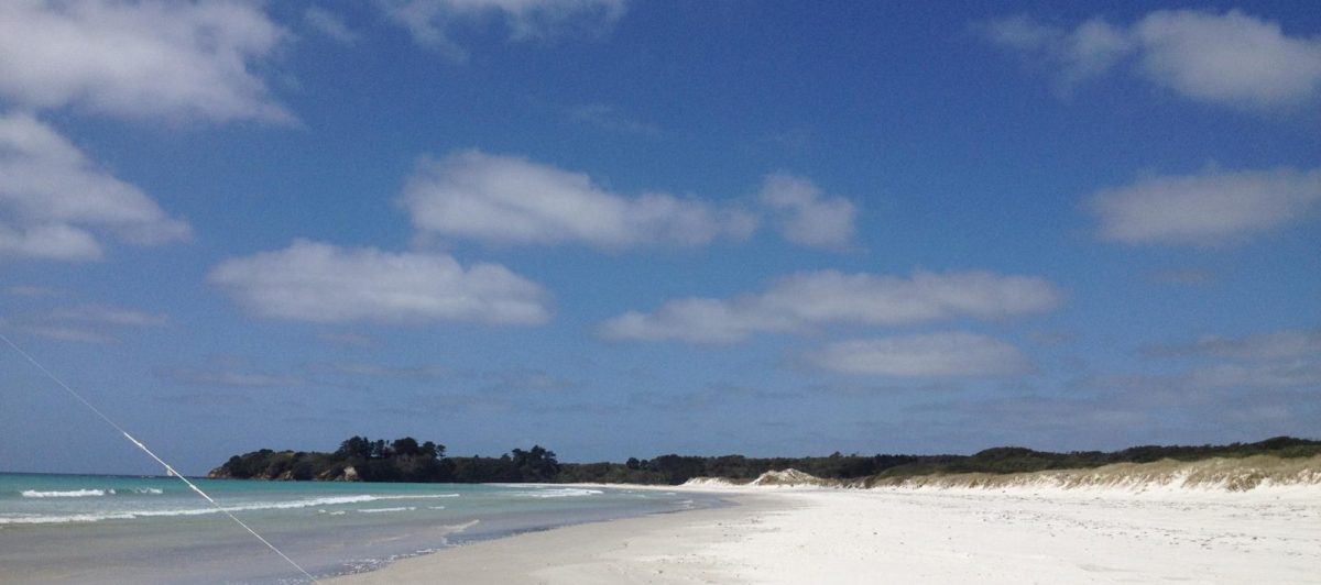
At Uretiti someone had obviously gone to some trouble to build a permanent path through the dunes to the beach.  It was paved at the base and posts had been placed either side of the paving.  However the sand, wind and sea had had no respect for the effort and in the section immediately behind the fore dune had proceeded to cover the path in sand to the extent of threequarter burying the marker posts.  Shows how little we count in the bigger scheme of things.

12 path   14 path   

And now back on track.  We left Uretiti and went up to Whangarei where we parked in the Town Basin right on the waterfront.  Very central to the City and handy all the amenities we require.  

19basin 20basin

This building was most intriguing as from a distance it appeared to be a hill with some strange buildings atop.  On closer inspection it turned out to be the local theatre.  On mentioning it to some locals we were advised that it had generated a lot of comment, most of which was adverse.

21 theatre21basin

Also along the same piece of foreshore these stone sculptures were placed but I did not get close enough  to read about them.

In the basin itself were a large number of pleasure boats with a small number of working boats.

22basin 

Interpretive signs were placed at points along the walkway beside the river edge and sculptures were everywhere. This one is said to represent seagulls landing but also double as seats for people to relax in.

23seagull

This one is steel covered with carved acrylic, the seagull adding the feather in the hair of the head on the top

24sculpture 

After two days and nights, during which we stocked up for the next part of our trip,  we were underway again heading further North to Kerikeri.  We started off in convoy with Brian and Marj leading the way.

26follow

Along the way we headed through Moerewa, which brought back a few memories for Bernice. This is where her Uncle and family lived for some time and where the two families met up before spending summer holidays on their respective boats in and around the Bay of Islands in the mid to late 1960’s.  The house seems to have shrunk over time!! Who would have thought that they, with 5 children and us with 6 children all managed to squeeze in there somehow?

27moerewa 28house

It was a short haul to Kerikeri and a very good parking spot in front of the RSA.

34rsa

Roy’s cousin Stuart came for quick visit with promises made to spend more time on our return journey.  We did manage to visit Kemp House and the Stone Store though.

31kemphouse Kemp House Kerikeri

32bridge   Where the bridge used to be over the river in Kerikeri, in front of the Stone Store.

After more stocking up and filling up with fuel, we were off again in our ‘race’ to Cape Reinga.  Of course our version of a race is very different to what it once was, with each of these travel legs only around 100kms.  And of course we have to stop along the way for a morning cuppa! 

35morning tea  here we are parked in a rest area having our morning tea.

Between Kerikeri and Mongonui we were part of a 4 van convoy with two others joining us. 

38convoy We have a convoy!

It was not long before we arrived in Kaitaia, our last stop before heading as far north as we can go.  We parked in the RSA car park for the night and even managed a quick visit to friends before pulling out on Saturday morning. Managed to call Alexandra in London for her birthday, Happy 27th Birthday Alex! 

39 rsa Parked in Kaitaia

Saturday morning and we headed off out of Kaitaia for the final leg of our sprint north before we turn around and meander our way south again.  But before leaving Kaitaia, it was off to the dump station where we saw this sign…. 

40sign Obviously Pirates have been and stolen their Rrrrrr’s!

The final stretch of road north was not quite what we expected, a lot more meandering and hillier than we expected and with the gusts of wind building the further north we got, it made for an interesting drive.   We reached Cape Reinga car park for a quick stop before deciding to head off to our parking spot for the next few days.  We will return over the next few days for the walk out to the Lighthouse and to see the meeting of the waters, hopefully when the weather is a little kinder.

 41beach Looking across to Cape Maria van Diemen

42lighthouse the Lighthouse in the distance, and a close up.

43lighthouse

Off over the hills and down the dales and round some hairpin bends to the DOC camp at Tapotupotu. 

44TapotupotuHere we are parked up and settled in for the next few days.  Oh and of course at this end of the country, there is no internet, no phone, no radio…..holidays like they used to be!!

PS. We do of course have Satellite TV, so not completely cut off from the world!

Uretiti

With a view like this, is it any wonder that we have been a little slack in updating the blog.

20130806-102308.jpg
It’s been a week since we arrived here at Uretiti and we are relaxing into Northland life. The weather wasn’t the greatest for a couple of days last week, in fact it was wet, misty and downright dull. But never mind, it was still lovely to be here parked in the quiet.

20130806-102704.jpg
We did drag ourselves away from the beach for a few trips out and about. Friday we caught up with Di & Dave who used to have a fabulous restaurant in Oamaru, although we actually only caught up with Di as David is currently in the UK. It was great to meet up, and great to see where they live out on the Whangarei Heads at McLeods Bay. Saturday and we headed south this time through Waipu and Langs Beach

20130806-103301.jpg
Onto Mangawhai Heads where we again caught up with friends from a long time ago. This time we met up with Bruce & Heather Rogan. Roy knew them both from Uni days, and from when Roy & Bruce worked at IBM as well as the old NZFP days when Roy was DP Manager (in the days before it was called IT) and Bruce was at IBM. It was fantastic to see them after such a longtime, and we spent a lovely day reminiscing.

In between, we have managed to check out the towns of both Waipu and Ruakaka whilst replenishing stocks and adding to the local economy. The weather has been very warm, so much so we have removed the winter duvet from the bed and we are looking at the summer clothes thinking that they will be out of the cupboard soon. Although of course as soon as we removed the winter duvet off the bed, the night time temperature has been cool. But that’s what happens when there is no cloud cover to keep in the warmth.

The plan, if you can call it a plan, is to leave Uretiti today and head into Whangarei for two nights to attend to a few chores and stock up before heading to Kerikeri for a brief stop over to meet up with friends, then onto Kaitaia for any last minute purchases before heading up to Cape Reinga. From there we will spend the next few months slowly working our way back southwards toward Auckland. We are doing it this way so that Marjorie and Brian can accompany us to the Cape and to points south of there until they have to leave us and head off at the end of August.

And now, what you have all been eagerly awaiting, the answer to the guess-what-the-doofer-is game, here it is made up

20130806-103707.jpgNo Don, it is not a hoofer doofer, and John some of us don’t rush to google to work it out, so Alex gets the prize for correctly guessing that it is for placing your hamburger in to eat so that all the contents do not spill out. Another couple of guesses were a rocking cradle for a pet mouse or a chip holder. The prize is of course the doofer!

Reflections

Time to reflect on our extended time in Auckland particularly from the perspective of visitors to the city. Firstly, we must say that we like Auckland, it’s vibrant, colourful, and diverse with lots of lovely beaches, parks and trees, and we really do mean lost of trees everywhere, it is very evident when you look out over the city at just how lush and green it really is.

Of course we love Auckland for the opportunity to see family and friends. Two sons, Simon and Antony are in Auckland and it is always lovely to see them both and catch up with them and Simons wife Anita. Then there is family with brother Seve and his wife Leslie, their daughters and grandchildren to catch up on, cousins, nieces, nephews as well. Then there are friends, friends from Roy’s days of growing up in Auckland and friendships made over the years of us living and working in Auckland. What is really great about all these people is that it seems as though we only saw them a day or so ago. We didn’t manage to catch up with everyone, however….we will be back!

What we don’t particularly enjoy is the traffic, BUT, it is just a fact of life of being in a big city and you have to allow plenty of time to get from A to B. And just as well we know the roads very well as if we followed the GPS or the non existent signs, goodness knows where we would end up. We do have to say that from the perspective of a visitor to Auckland, the road signage is very poor, particularly if you need to get from the airport (or Ambury) into the city or onto the Harbour Bridge. The signs are either non existent, badly placed, very small or terribly worded. And when roads change names halfway along, it does not help. For example; Manukau Road (which is the main route from the northern motorway exit or city to the South west Motorway I.e. airport) changes its name to Pah Road, which then becomes Queenstown Road, and is signposted as Queenstown Road exit off the motorway. Unless you know that this is the road/exit you need, you could well drive on by. As I said, local knowledge is key, and knowing easier, shorter and better routes than the GPS is also helpful.

Then there is the food. The markets and shops with all ethnic variations catered for, we really really enjoy this part of Auckland. From the shops such as Sabato, Farro and Nosh through to the Chinese & Korean Supermarkets and all the fabulous farmers markets, we loved them all. And yes Jacky, that includes spending time with you in the kitchen cooking up a storm. Cooking/eating with Steve and Les is always a pleasure and this time it was great to be part of the great bacon making as well as sampling the salami and sausages.

Then there are the Regional Parks, what a huge asset to the city. Where else in the world can you camp in a Park, surrounded by farmland just 15 minutes from the centre of the city? The Parks are dotted all around the region and in some stunning locations. We have really enjoyed visiting a few more of the 26 Parks.

All in all a great time in Auckland. Thanx to everyone who made our extended time in the big smoke so pleasurable. See you next time!